The calculation was made with glide ratio 20, safety 250m, ground clearance 200m.
Alos topo data 30m.
Cartographic data are a mix of Copernicus satellite layers and OpenStreetMaps (OSM) data. The software used is QGIS (free).
The summits come from OSM and have been sorted so that only the highest within a 5km radius remains.
The passes are selected in a way that is not yet suitable, but they only appear at the highest zoom level. Eventually, the filter is intended to be: "all passes that are key points for getting back to a terrain, even if it's not the nearest one". Still, there are plenty of interesting passes.
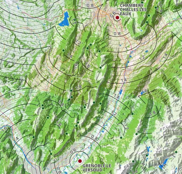
Reading tutorial:
Zoomed out, you can see colored zones. Each color corresponds to the locality of a terrain, and the lines separating the colors are the locality change lines between terrains.
When you zoom out a little, the color is still very slightly present, and the lines appear.
Taking the Chartreuse massif as an example, on the west side of the Rhône valley, we can see that the place where the calculation changes from the theoretical Challes-les-Eaux local to the Grenoble local is the town of Saint-Laurent-Du-Pont, around 1950m (1.8 = 1800m, a large line every 200m, a small one every 50m).
You can see that there are two paths to Grenoble (Voreppe -> Grenoble ville -> Grenoble airfield, and Sud Grande Sure -> around Mont Jalla -> Grenoble airfield).
This example is perfect for showing the possibilities and limits of this map:
We can clearly see the areas of change of location and the optimal trajectories (going towards the center of the arcs of circles), which take into account detours and passes, and the altitudes of change of location,
BUT
The limitations of the usual glide radio circles (calm air works, but if there's a lot of wind, thunderstorms or airspace, just because the circle says you're local doesn't mean you are) are also the limitations of this map. One day, perhaps, the calculation will include airspace. And of course, the calculation doesn't take into account routes, downdrafts and weather.
More informations are available here and here.
|